
Oberland topographic map
Interactive map
Click on the map to display elevation.
About this map
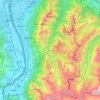
Name: Oberland topographic map, elevation, terrain.
Location: Oberland, Liechtenstein (47.04843 9.47167 47.19423 9.63571)
Average elevation: 4,058 ft
Minimum elevation: 1,424 ft
Maximum elevation: 9,308 ft
Other topographic maps
Click on a map to view its topography, its elevation and its terrain.
Malbun
Malbun, Triesenberg, Oberland, Liechtenstein
Average elevation: 5,846 ft
Schaan
Liechtenstein > Oberland > Schaan
Schaan, Oberland, 9494, Liechtenstein
Average elevation: 3,412 ft
Triesen
Liechtenstein > Triesen > Triesen
Triesen, Wahlkreis Oberland, 9495, Liechtenstein
Average elevation: 2,165 ft
Falknis
Falknis, Triesen, Wahlkreis Oberland, Liechtenstein
Average elevation: 6,611 ft
Schloss Vaduz
Schloss Vaduz, Fürst-Franz-Josef-Strasse, Vaduz, Wahlkreis Oberland, 9490, Liechtenstein
Average elevation: 2,326 ft