Geolocate

North Karachi topographic map

Click on the map to display elevation.

About this map

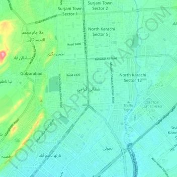
Name: North Karachi topographic map, elevation, terrain.

Location: North Karachi, Karachi Division, Sindh, 75850, Pakistan (24.93254 67.02695 25.01254 67.10695)

Average elevation: 174 ft

Minimum elevation: 79 ft

Maximum elevation: 574 ft

Other topographic maps

Click on a map to view its topography, its elevation and its terrain.

Orangi Town

Pakistan > Sindh > Karachi Division

Average elevation: 207 ft

Korangi Town

Pakistan > Sindh > Karachi Division

Average elevation: 26 ft

Jamshed Town

Pakistan > Sindh > Karachi Division

Average elevation: 66 ft

SITE Town

Pakistan > Sindh > Karachi Division

Average elevation: 125 ft

North Nazimabad Town

Pakistan > Sindh > Karachi Division

Average elevation: 138 ft

Mauripur Town

Pakistan > Sindh > Karachi Division

Average elevation: 33 ft

Gear up for your next adventure:

🥾Men's Hiking Boots - Durable, waterproof footwear for rugged terrain and steep inclines
Backpacking Tent - Lightweight and durable tent for multi‑day hikes
🔌Solar Panel Charger - Charge gear sustainably outdoors
💧Water Filtration Bottles - Safely drink from streams and lakes while exploring
🪶Wildlife Field Guides - Learn animal tracking and species ID

As an Amazon Associate, this site earns from qualifying purchases at no extra cost to you.