
Serra do Salitre topographic map
Interactive map
Click on the map to display elevation.
About this map
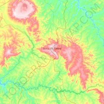
Name: Serra do Salitre topographic map, elevation, terrain.
Average elevation: 3,146 ft
Minimum elevation: 2,608 ft
Maximum elevation: 4,186 ft
The municipality is located in the region of the Alto Paranaíba, just north of the Nova Ponte Reservoir, which is fed by the Rio Anzol and the Ribeirão Santa Juliana. The elevation of the town center is 1,200 meters. Highway connections are made by local road to BR-365, which connects to Uberlândia. Neighboring municipalities are: Cruzeiro da Fortaleza and Lagoa Formosa(N); Rio Paranaíba (E); Ibiá and Perdizes(S); Patrocínio (W).