
Burton-on-Trent topographic map
Interactive map
Click on the map to display elevation.
About this map
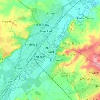
Name: Burton-on-Trent topographic map, elevation, terrain.
Average elevation: 226 ft
Minimum elevation: 125 ft
Maximum elevation: 489 ft
Burton is about 109 miles (175 km) north west of London, about 30 miles north east of Birmingham, the UK's second largest city and about 23 miles east of the county town Stafford. It is at the easternmost border of the county of Staffordshire with Derbyshire, its suburbs and the course of the River Trent forming part of the county boundary. It is also near the south-eastern terminus of the Trent and Mersey Canal. Burton lies within the northern boundary of the National Forest. The town centre is on the western bank of the River Trent in a valley bottom; its average elevation is about 50 metres above sea level; the village of Winshill and the suburb of Stapenhill rise to 130 m and 100 m respectively.
Other topographic maps
Click on a map to view its topography, its elevation and its terrain.
Gratwich
United Kingdom > England > Staffordshire > East Staffordshire > Kingstone
Gratwich, Kingstone, East Staffordshire, Staffordshire, England, ST14 8WE, United Kingdom
Average elevation: 469 ft