
Make a donation
Gear up for your next adventure:
As an Amazon Associate, this site earns from qualifying purchases at no extra cost to you.
Azufral topographic map
Click on the map to display elevation.
Make a donation
Gear up for your next adventure:
As an Amazon Associate, this site earns from qualifying purchases at no extra cost to you.
Azufral
Azufral is a stratovolcano located in the department of Nariño in southern Colombia, 12 km (7 mi) west of the town of Túquerres. It is the only volcano of the Western Ranges of the Colombian Andes. Its name derives from the Spanish word for sulfur, azufre. The volcano is considered semi-dormant but there are numerous fumaroles in the summit crater. The summit of the volcano has an altitude of 4,070 metres (13,350 ft),[1] and the north-western side of the crater contains a crescent-shaped lake named Laguna Verde (English: Green Lake) at 3,970 m (13,025 ft). The lake is 1,100 m (0.68 mi) long and 600 metres (2,000 ft) wide.[2] and its bright green color is a result of the sulfur and iron-based deposits in the crater. There are also two other much smaller lakes in the crater, Laguna Negra (English: Black Lake) and Laguna Cristal (English: Crystal Lake).
Make a donation
Gear up for your next adventure:
As an Amazon Associate, this site earns from qualifying purchases at no extra cost to you.
About this map
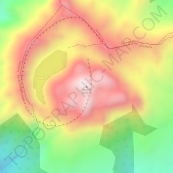
Name: Azufral topographic map, elevation, terrain.
Location: Azufral, Sapuyes, La Sabana, Nariño, Colombia (1.08549 -77.71864 1.08559 -77.71854)
Average elevation: 12,372 ft
Minimum elevation: 11,224 ft
Maximum elevation: 13,251 ft
Make a donation
Gear up for your next adventure:
As an Amazon Associate, this site earns from qualifying purchases at no extra cost to you.