
Ambazac topographic map
Interactive map
Click on the map to display elevation.
About this map
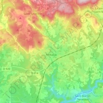
Name: Ambazac topographic map, elevation, terrain.
Average elevation: 1,378 ft
Minimum elevation: 797 ft
Maximum elevation: 2,234 ft
Other topographic maps
Click on a map to view its topography, its elevation and its terrain.
Bussignet
France > Nouvelle-Aquitaine > Haute-Vienne > Ambazac > Bussignet
Bussignet, Ambazac, Limoges, Haute-Vienne, Nouvelle-Aquitaine, France métropolitaine, 87240, France
Average elevation: 1,148 ft