
Underberg topographic map
Click on the map to display elevation.
About this map
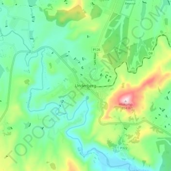
Name: Underberg topographic map, elevation, terrain.
Average elevation: 5,092 ft
Minimum elevation: 4,642 ft
Maximum elevation: 6,237 ft
Other topographic maps
Click on a map to view its topography, its elevation and its terrain.
Umzimkulu
South Africa > KwaZulu-Natal > Sisonke District Municipality > Kwa Sani Local Municipality
Average elevation: 4,997 ft
Umzimkulu
South Africa > KwaZulu-Natal > Sisonke District Municipality > Kwa Sani Local Municipality
Average elevation: 4,977 ft
Goxhil Dam
South Africa > KwaZulu-Natal > Sisonke District Municipality > Kwa Sani Local Municipality
Average elevation: 4,951 ft
Kwa Sani Local Municipality
South Africa > KwaZulu-Natal > Sisonke District Municipality > Kwa Sani Local Municipality
Average elevation: 6,250 ft