
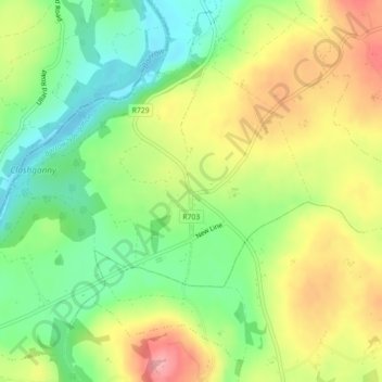
Coolnamara Cross Roads topographic map
Interactive map
Click on the map to display elevation.
About this map
Name: Coolnamara Cross Roads topographic map, elevation, terrain.
Average elevation: 213 ft
Minimum elevation: 33 ft
Maximum elevation: 436 ft
Other topographic maps
Click on a map to view its topography, its elevation and its terrain.
St Mullins
St Mullins, The Municipal District of Muinebeag, The Municipal District of New Ross, County Carlow, Leinster, Ireland
Average elevation: 453 ft
Greenoge
Greenoge, The Municipal District of Tullow, County Carlow, Leinster, Ireland
Average elevation: 892 ft
Slievebawn
Slievebawn, The Municipal District of Muinebeag, County Carlow, Leinster, Ireland
Average elevation: 1,033 ft
Myshall
Myshall, Myshall ED, The Municipal District of Tullow, County Carlow, Leinster, Ireland
Average elevation: 476 ft
Oak Park
Oak Park, Carlow Rural ED, The Municipal District of Carlow, County Carlow, Leinster, Ireland
Average elevation: 194 ft
Leighlinbridge
Leighlinbridge, Leighlinbridge ED, The Municipal District of Muinebeag, County Carlow, Leinster, Ireland
Average elevation: 171 ft
Agharue
Agharue, Rathornan ED, The Municipal District of Muinebeag, County Carlow, Leinster, Ireland
Average elevation: 774 ft
The Municipal District of Tullow
The Municipal District of Tullow, County Carlow, Leinster, Ireland
Average elevation: 367 ft
The Municipal District of Muinebeag
The Municipal District of Muinebeag, County Carlow, Leinster, Ireland
Average elevation: 423 ft
Kinneagh Parish
Kinneagh Parish, The Municipal District of Tullow, County Carlow, Leinster, Ireland
Average elevation: 381 ft
Ballinabranagh
Ballinabranagh, Clogrenan ED, The Municipal District of Muinebeag, County Carlow, Leinster, Ireland
Average elevation: 407 ft
Ballintemple
Ballintemple, Ballintemple ED, The Municipal District of Tullow, County Carlow, Leinster, Ireland
Average elevation: 305 ft
Killenora
Killenora, Johnstown ED, The Municipal District of Carlow, County Carlow, Leinster, Ireland
Average elevation: 240 ft
Rathornan
Rathornan, Rathornan ED, The Municipal District of Muinebeag, County Carlow, Leinster, Ireland
Average elevation: 171 ft
Lumcloon
Lumcloon, Fennagh ED, The Municipal District of Muinebeag, County Carlow, Leinster, Ireland
Average elevation: 315 ft
Kellistown
Kellistown, The Municipal District of Tullow, County Carlow, Leinster, Ireland
Average elevation: 299 ft
The Municipal District of Carlow
The Municipal District of Carlow, County Carlow, Leinster, Ireland
Average elevation: 233 ft