
Schweigen-Rechtenbach topographic map
Interactive map
Click on the map to display elevation.
About this map
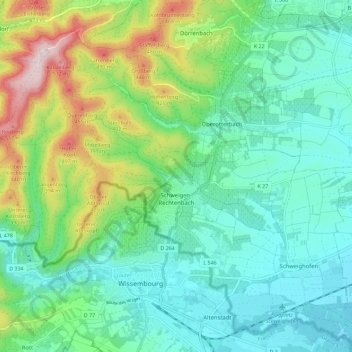
Name: Schweigen-Rechtenbach topographic map, elevation, terrain.
Average elevation: 827 ft
Minimum elevation: 453 ft
Maximum elevation: 1,844 ft
Other topographic maps
Click on a map to view its topography, its elevation and its terrain.
Annweiler am Trifels
Allemagne > Rhénanie-Palatinat > Landkreis Südliche Weinstraße
Annweiler am Trifels, Landkreis Südliche Weinstraße, Rhénanie-Palatinat, Allemagne
Average elevation: 1,112 ft