
Isla de Mona e Islote Monito topographic map
Interactive map
Click on the map to display elevation.
About this map
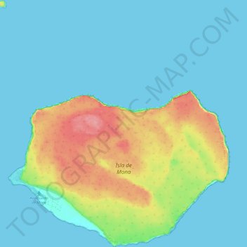
Name: Isla de Mona e Islote Monito topographic map, elevation, terrain.
Average elevation: 66 ft
Minimum elevation: -3 ft
Maximum elevation: 289 ft
Other topographic maps
Click on a map to view its topography, its elevation and its terrain.
Mayagüez
United States > Puerto Rico > Mayagüez
Mayagüez, Puerto Rico, 00680, United States
Average elevation: 305 ft