
Haidian District topographic map
Interactive map
Click on the map to display elevation.
About this map
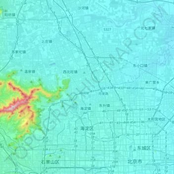
Name: Haidian District topographic map, elevation, terrain.
Location: Haidian District, Beijing, China (39.88531 116.04255 40.15981 116.38883)
Average elevation: 230 ft
Minimum elevation: 79 ft
Maximum elevation: 2,585 ft
Other topographic maps
Click on a map to view its topography, its elevation and its terrain.
正白旗村
China > Beijing > Haidian District > 正白旗村
正白旗村, Haidian District, Beijing, 100193, China
Average elevation: 157 ft
Qinghe
China > Beijing > Haidian District > Qinghe
Qinghe, Haidian District, Beijing, 100085, China
Average elevation: 154 ft