
Make a donation
Gear up for your next adventure:
As an Amazon Associate, this site earns from qualifying purchases at no extra cost to you.
Gerlos topographic map
Click on the map to display elevation.
Make a donation
Gear up for your next adventure:
As an Amazon Associate, this site earns from qualifying purchases at no extra cost to you.
Gerlos
Gerlos is located in the de:Gerlostal, which is a side valley of the Zillertal, branching to the east near Zell am Ziller. Gerlos consists of several hamulated located along the de:Gerlospass on the floor of the valley, at an altitude of around 1200m. To the south, the side valleys of de:Schwarzach, de:Wimmerbach, and de:Schönach lead to the Zillertal Alps, which are over 3000 meters tall. To the north, there is a ski area on the Kitzbuhel Alps.
Make a donation
Gear up for your next adventure:
As an Amazon Associate, this site earns from qualifying purchases at no extra cost to you.
About this map
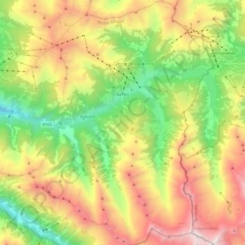
Name: Gerlos topographic map, elevation, terrain.
Location: Gerlos, Bezirk Schwaz, Tyrol, 6281, Austria (47.13869 11.95610 47.27949 12.11112)
Average elevation: 6,319 ft
Minimum elevation: 3,064 ft
Maximum elevation: 10,646 ft
Make a donation
Gear up for your next adventure:
As an Amazon Associate, this site earns from qualifying purchases at no extra cost to you.