
Bot River topographic map
Interactive map
Click on the map to display elevation.
About this map
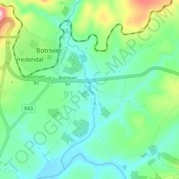
Name: Bot River topographic map, elevation, terrain.
Average elevation: 279 ft
Minimum elevation: 39 ft
Maximum elevation: 988 ft
Other topographic maps
Click on a map to view its topography, its elevation and its terrain.
Theewaterskloof Ward 12
RSA > Western Cape > Theewaterskloof Local Municipality
Theewaterskloof Ward 12, Theewaterskloof Local Municipality, Overberg District Municipality, Western Cape, RSA
Average elevation: 1,260 ft
Klein River
RSA > Western Cape > Theewaterskloof Local Municipality
Klein River, Theewaterskloof Local Municipality, Overberg District Municipality, Western Cape, RSA
Average elevation: 627 ft
Lebanon Nature Reserve
RSA > Western Cape > Theewaterskloof Local Municipality
Lebanon Nature Reserve, N2, Theewaterskloof Ward 7, Theewaterskloof Local Municipality, Overberg District Municipality, Western Cape, 7160, RSA
Average elevation: 1,007 ft
Greyton Nature Reserve
RSA > Western Cape > Theewaterskloof Local Municipality
Greyton Nature Reserve, Boesmankloof Hiking Trail, Theewaterskloof Ward 2, Theewaterskloof Local Municipality, Overberg District Municipality, Western Cape, RSA
Average elevation: 2,211 ft
Vrolijkheid Nature Reserve
RSA > Western Cape > Theewaterskloof Local Municipality
Vrolijkheid Nature Reserve, Theewaterskloof Ward 1, Theewaterskloof Local Municipality, Overberg District Municipality, Western Cape, RSA
Average elevation: 1,332 ft