
Make a donation
Gear up for your next adventure:
As an Amazon Associate, this site earns from qualifying purchases at no extra cost to you.
Mata de Santa Genebra topographic map
Click on the map to display elevation.
Make a donation
Gear up for your next adventure:
As an Amazon Associate, this site earns from qualifying purchases at no extra cost to you.
Mata de Santa Genebra
Altitude ranges from 585 to 615 metres (1,919 to 2,018 ft). The terrain mainly takes the form of shallow sloped hollows holding deep and mature clay soils. Temperatures range from 0 to 38 °C (32 to 100 °F) with an average of 22 °C (72 °F). The unit is in the Atlantic Forest biome. 92% of the area is covered by semi-deciduous upland forest, and 8% by swamp forest. The unit holds a remnant of semi-deciduous forest in the centre of a highly populated region, the Campinas Metropolitan Region. Human actions and natural causes have degraded some of the natural plant communities, and the unit now contains areas of secondary growth.
Make a donation
Gear up for your next adventure:
As an Amazon Associate, this site earns from qualifying purchases at no extra cost to you.
About this map
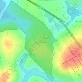
Name: Mata de Santa Genebra topographic map, elevation, terrain.
Average elevation: 2,001 ft
Minimum elevation: 1,903 ft
Maximum elevation: 2,133 ft
Make a donation
Gear up for your next adventure:
As an Amazon Associate, this site earns from qualifying purchases at no extra cost to you.