
Make a donation
Gear up for your next adventure:
As an Amazon Associate, this site earns from qualifying purchases at no extra cost to you.
Itlay Hisage topographic map
Click on the map to display elevation.
Make a donation
Gear up for your next adventure:
As an Amazon Associate, this site earns from qualifying purchases at no extra cost to you.
About this map
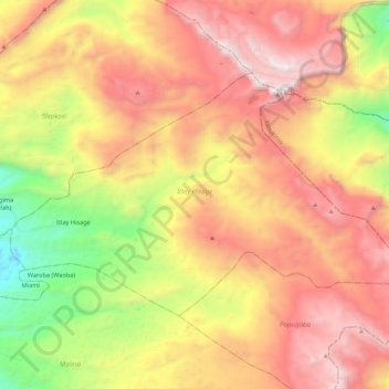
Name: Itlay Hisage topographic map, elevation, terrain.
Average elevation: 9,656 ft
Minimum elevation: 6,027 ft
Maximum elevation: 12,930 ft
Make a donation
Gear up for your next adventure:
As an Amazon Associate, this site earns from qualifying purchases at no extra cost to you.
Other topographic maps
Click on a map to view its topography, its elevation and its terrain.
Wamena
Indonesia > Highland Papua > Jayawijaya
Wamena features a tropical rainforest climate (Köppen Af), albeit a relatively mild version due to its high altitude.
Average elevation: 7,503 ft
Make a donation
Gear up for your next adventure:
As an Amazon Associate, this site earns from qualifying purchases at no extra cost to you.