Geolocate

Mount Vernon topographic map

Click on the map to display elevation.

About this map

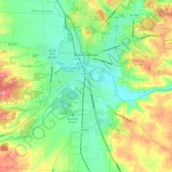
Name: Mount Vernon topographic map, elevation, terrain.

Location: Mount Vernon, Knox County, Ohio, 43050, United States (40.33786 -82.51720 40.41926 -82.43024)

Average elevation: 1,079 ft

Minimum elevation: 948 ft

Maximum elevation: 1,280 ft

Knox County trails, hiking, mountain biking, running and outdoor activities

Other topographic maps

Click on a map to view its topography, its elevation and its terrain.

Zuck

United States > Ohio > Knox County

Average elevation: 968 ft

Howard

United States > Ohio > Knox County

Average elevation: 978 ft

Howard

United States > Ohio > Knox County

Average elevation: 978 ft

Gear up for your next adventure:

🥾Hiking Shoes - Durable and comfortable shoes for trail hiking
☀️Outdoor Sunscreen - High protection sunscreen for outdoor activities
🛌Ultralight Sleeping Bags - Compact down bags for cold nights in the wilderness
🌄Hiking Binoculars - Compact binoculars for scenic views and trail spotting
🚑Emergency Bivvies - Heat-reflective sleeping bags for survival situations

As an Amazon Associate, this site earns from qualifying purchases at no extra cost to you.