
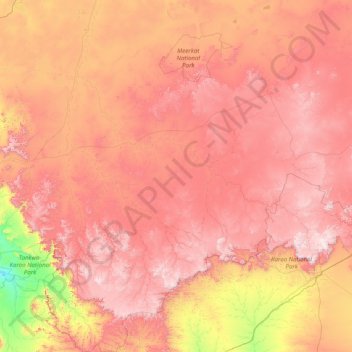
Karoo Hoogland Ward 3 topographic map
Interactive map
Click on the map to display elevation.
About this map
Name: Karoo Hoogland Ward 3 topographic map, elevation, terrain.
Average elevation: 3,612 ft
Minimum elevation: 1,007 ft
Maximum elevation: 6,371 ft
Other topographic maps
Click on a map to view its topography, its elevation and its terrain.
Klein-Leeukop
South Africa > Northern Cape > Namakwa District Municipality > Karoo Hoogland Local Municipality
Klein-Leeukop, Karoo Hoogland Local Municipality, Namakwa District Municipality, Northern Cape, South Africa
Average elevation: 5,299 ft
Hartbeeshoek
South Africa > Northern Cape > Namakwa District Municipality > Karoo Hoogland Local Municipality
Hartbeeshoek, Karoo Hoogland Local Municipality, Namakwa District Municipality, Northern Cape, South Africa
Average elevation: 2,224 ft
Fraserburg
South Africa > Northern Cape > Namakwa District Municipality > Karoo Hoogland Local Municipality > Fraserburg
Fraserburg, Karoo Hoogland Local Municipality, Namakwa District Municipality, Northern Cape, 6960, South Africa
Average elevation: 4,160 ft
Williston
South Africa > Northern Cape > Namakwa District Municipality > Karoo Hoogland Local Municipality
Williston, Karoo Hoogland Local Municipality, Namakwa District Municipality, Northern Cape, South Africa
Average elevation: 3,596 ft
Karoo Hoogland Local Municipality
South Africa > Northern Cape > Namakwa District Municipality > Karoo Hoogland Local Municipality
Karoo Hoogland Local Municipality, Namakwa District Municipality, Northern Cape, 6960, South Africa
Average elevation: 3,612 ft