
Mount Warren topographic map
Interactive map
Click on the map to display elevation.
About this map
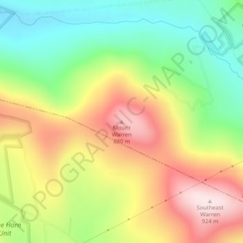
Name: Mount Warren topographic map, elevation, terrain.
Location: Mount Warren, Town of Bovina, Delaware County, New York, USA (42.31476 -74.70465 42.31486 -74.70455)
Average elevation: 2,221 ft
Minimum elevation: 1,572 ft
Maximum elevation: 2,995 ft
Other topographic maps
Click on a map to view its topography, its elevation and its terrain.
Staten Island
Staten Island, Richmond County, New York, USA
Average elevation: 36 ft
East Maine
USA > New York > East Maine
East Maine, Maine Town, Broome County, New York, USA
Average elevation: 1,421 ft
Buchanan
USA > New York > Buchanan > Town of Cortlandt
Buchanan, Town of Cortlandt, Westchester County, New York, 10511, USA
Average elevation: 89 ft
Twin Mountains
Twin Mountains, Franklin County, New York, USA
Average elevation: 1,814 ft
Livingston Island
Livingston Island, Town of Philipstown, Putnam County, New York, 10922, USA
Average elevation: 512 ft
Falls Creek
Falls Creek, Town of Delhi, Delaware County, New York, 13753, USA
Average elevation: 1,690 ft
Flat Top Mountain
Flat Top Mountain, Franklin County, New York, USA
Average elevation: 1,864 ft
Avalanche Lake
Avalanche Lake, Avalanche Pass Trail, Essex County, New York, USA
Average elevation: 3,497 ft
Big Bear Mountain
Big Bear Mountain, Town of Johnsburg, Warren County, New York, USA
Average elevation: 2,021 ft