Geolocate

Manistique topographic map

Click on the map to display elevation.

About this map

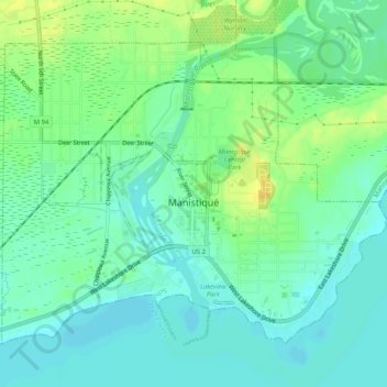
Name: Manistique topographic map, elevation, terrain.

Location: Manistique, Schoolcraft County, Michigan, United States (45.94470 -86.27178 45.97248 -86.22078)

Average elevation: 594 ft

Minimum elevation: 564 ft

Maximum elevation: 646 ft

Schoolcraft County trails, hiking, mountain biking, running and outdoor activities

Other topographic maps

Click on a map to view its topography, its elevation and its terrain.

Dinner Lake

United States > Michigan > Schoolcraft County

Average elevation: 791 ft

Germfask

United States > Michigan > Schoolcraft County

Average elevation: 702 ft

Gear up for your next adventure:

🛡️Insect Repellent - Protection against bugs during outdoor activities
🥾Men's Hiking Boots - Durable, waterproof footwear for rugged terrain and steep inclines
🧭Hiking Compass - Precision compass for reliable navigation in the wilderness
🏥Hiking First Aid Kits - Comprehensive medical kits for remote trail injuries
🕶️GPS Smartphone Mount - Secure mount for phone navigation

As an Amazon Associate, this site earns from qualifying purchases at no extra cost to you.