
Remedios topographic map
Interactive map
Click on the map to display elevation.
About this map
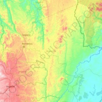
Name: Remedios topographic map, elevation, terrain.
Location: Remedios, Nordeste, Antioquia, Colombia (6.70019 -74.85729 7.26791 -74.24178)
Average elevation: 1,640 ft
Minimum elevation: 256 ft
Maximum elevation: 4,606 ft
Other topographic maps
Click on a map to view its topography, its elevation and its terrain.
San Vicente
San Vicente, Oriente, Antioquia, RAP del Agua y la Montaña, Colombia
Average elevation: 7,087 ft
Nendo
Colombia > Antioquia > La Condota
Nendo, La Condota, Urrao, Suroeste, Antioquia, Colombia
Average elevation: 3,386 ft