
Cártama topographic map
Interactive map
Click on the map to display elevation.
About this map
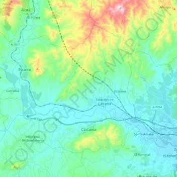
Name: Cártama topographic map, elevation, terrain.
Location: Cártama, Valle del Guadalhorce, Malaga, Andalusia, Spain (36.68762 -4.77897 36.80976 -4.56898)
Average elevation: 568 ft
Minimum elevation: 30 ft
Maximum elevation: 2,572 ft
The original town, Cártama Pueblo, stretches across the steep side of the Hill of the Virgin (240 m over the sea level). Its buildings and roads follow the contours of the hill, and reflect the varied topography of the area.
Other topographic maps
Click on a map to view its topography, its elevation and its terrain.
Almogía
Spain > Andalusia > Valle del Guadalhorce
Almogía, Valle del Guadalhorce, Malaga, Andalusia, 29150, Spain
Average elevation: 1,270 ft