
Waurika topographic map
Interactive map
Click on the map to display elevation.
About this map
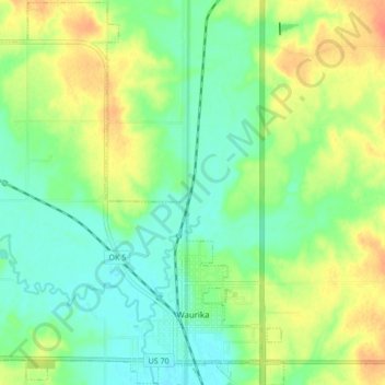
Name: Waurika topographic map, elevation, terrain.
Location: Waurika, Jefferson County, Oklahoma, 73573, United States (34.15414 -98.05193 34.22460 -97.97739)
Average elevation: 925 ft
Minimum elevation: 869 ft
Maximum elevation: 1,007 ft
Waurika Lake, completed in 1980, is 11 miles long, contains 192,000 acre feet of water at its normal elevation of 951 feet, has a surface area of 10,000 acres, and features 80 miles of shoreline.
Other topographic maps
Click on a map to view its topography, its elevation and its terrain.
Ryan
United States > Oklahoma > Jefferson County
Ryan, Jefferson County, Oklahoma, 73565, United States
Average elevation: 876 ft
Oscar
United States > Oklahoma > Jefferson County
Oscar, Jefferson County, Oklahoma, United States
Average elevation: 853 ft
Petersburg
United States > Oklahoma > Jefferson County
Petersburg, Jefferson County, Oklahoma, United States
Average elevation: 823 ft
Sugden
United States > Oklahoma > Jefferson County
Sugden, Jefferson County, Oklahoma, United States
Average elevation: 873 ft
Grady
United States > Oklahoma > Jefferson County
Grady, Jefferson County, Oklahoma, United States
Average elevation: 846 ft
Cornish
United States > Oklahoma > Jefferson County
Cornish, Jefferson County, Oklahoma, United States
Average elevation: 863 ft
Terral
United States > Oklahoma > Jefferson County
Terral, Jefferson County, Oklahoma, United States
Average elevation: 843 ft
Ringling
United States > Oklahoma > Jefferson County
Ringling, Jefferson County, Oklahoma, 73456, United States
Average elevation: 886 ft