
Urduliz topographic map
Interactive map
Click on the map to display elevation.
About this map
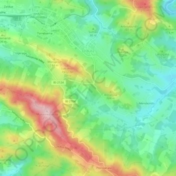
Name: Urduliz topographic map, elevation, terrain.
Average elevation: 295 ft
Minimum elevation: 0 ft
Maximum elevation: 791 ft
Other topographic maps
Click on a map to view its topography, its elevation and its terrain.
Getxo
Spain > Autonomous Community of the Basque Country > Andraka
Getxo, Andraka, Biscay, Autonomous Community of the Basque Country, 48620, Spain
Average elevation: 118 ft
Mungia
Spain > Autonomous Community of the Basque Country > Andraka
Mungia, Andraka, Biscay, Autonomous Community of the Basque Country, 48620, Spain
Average elevation: 364 ft
Plentzia
Spain > Autonomous Community of the Basque Country > Andraka
Plentzia, Andraka, Biscay, Autonomous Community of the Basque Country, 48620, Spain
Average elevation: 200 ft
Loiu
Spain > Autonomous Community of the Basque Country > Andraka
Loiu, Andraka, Biscay, Autonomous Community of the Basque Country, 48620, Spain
Average elevation: 230 ft