
Cheraia topographic map
Interactive map
Click on the map to display elevation.
About this map
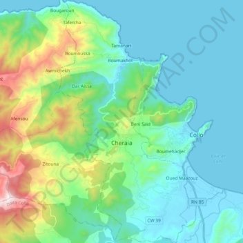
Name: Cheraia topographic map, elevation, terrain.
Location: Cheraia, Daïra Collo, Skikda, Algérie (36.94108 6.46411 37.08832 6.56384)
Average elevation: 797 ft
Minimum elevation: -3 ft
Maximum elevation: 3,845 ft
Other topographic maps
Click on a map to view its topography, its elevation and its terrain.
Beni Zid
Algérie > Skikda > Daïra Collo > Beni Zid
Beni Zid, Daïra Collo, Skikda, 21016, Algérie
Average elevation: 1,106 ft