
Grays Peak topographic map
Interactive map
Click on the map to display elevation.
About this map
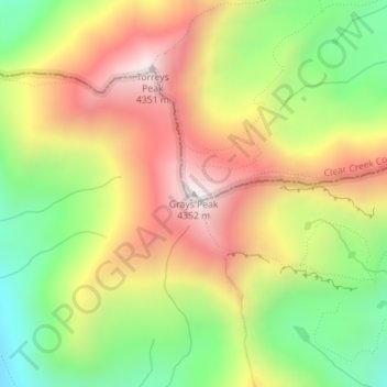
Name: Grays Peak topographic map, elevation, terrain.
Location: Grays Peak, Clear Creek County, Colorado, United States (39.63383 -105.81756 39.63393 -105.81746)
Average elevation: 12,841 ft
Minimum elevation: 11,473 ft
Maximum elevation: 14,242 ft
Grays Peak is one of 53 fourteeners (mountains of over 14,000 feet (4,300 m) in elevation) in Colorado. Botanist Charles C. Parry made the first recorded ascent of the summit in 1861 and named the peak in honor of his botanist colleague Asa Gray. Gray did not see (and climb) the peak until 1872, eleven years later. Grays Peak is commonly mentioned in conjunction with adjacent Torreys Peak.
Other topographic maps
Click on a map to view its topography, its elevation and its terrain.
Blue Valley
United States > Colorado > Clear Creek County
Blue Valley, Clear Creek County, Colorado, 80254, United States
Average elevation: 9,731 ft
Mount Blue Sky
United States > Colorado > Clear Creek County
Mount Blue Sky, Clear Creek County, Colorado, United States
Average elevation: 13,143 ft
Berthoud Falls
United States > Colorado > Clear Creek County
Berthoud Falls, Clear Creek County, Colorado, United States
Average elevation: 11,014 ft
Breckinridge Peak
United States > Colorado > Clear Creek County
Breckinridge Peak, Clear Creek County, Colorado, United States
Average elevation: 11,932 ft
Loveland Pass
United States > Colorado > Clear Creek County
Loveland Pass, Clear Creek County, Colorado, United States
Average elevation: 11,939 ft
Georgetown
United States > Colorado > Clear Creek County
Georgetown, Clear Creek County, Colorado, 80444, United States
Average elevation: 9,757 ft
St. Mary's
United States > Colorado > Clear Creek County
St. Mary's, Clear Creek County, Colorado, United States
Average elevation: 10,764 ft
Idaho Springs
United States > Colorado > Clear Creek County > Idaho Springs > Idaho Springs
Idaho Springs, Clear Creek County, Colorado, 80452, United States
Average elevation: 8,609 ft
Lawson
United States > Colorado > Clear Creek County > Lawson
Lawson, Clear Creek County, Colorado, 80436, United States
Average elevation: 9,075 ft
Idaho Springs
United States > Colorado > Clear Creek County
Idaho Springs, Clear Creek County, Colorado, 80452, United States
Average elevation: 8,737 ft