
Río La Silla topographic map
Interactive map
Click on the map to display elevation.
About this map
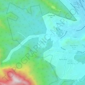
Name: Río La Silla topographic map, elevation, terrain.
Location: Río La Silla, Guadalupe, Nuevo León, México (25.57026 -100.31437 25.59258 -100.26332)
Average elevation: 2,651 ft
Minimum elevation: 1,864 ft
Maximum elevation: 5,741 ft
Other topographic maps
Click on a map to view its topography, its elevation and its terrain.
Parque Tepeyac
México > Nuevo León > Guadalupe
Parque Tepeyac, Residencial Las Avenidas, Guadalupe, Nuevo León, México
Average elevation: 1,703 ft
Pico Antena
México > Nuevo León > Guadalupe
Pico Antena, Guadalupe, Nuevo León, 67170, México
Average elevation: 3,921 ft
Rio la silla
México > Nuevo León > Guadalupe
Rio la silla, Guadalupe, Nuevo León, México
Average elevation: 1,444 ft
Ignacio Zaragoza
México > Nuevo León > Guadalupe
Ignacio Zaragoza, Guadalupe, Nuevo León, México
Average elevation: 1,575 ft