Geolocate

Kabankalan topographic map

Click on the map to display elevation.

About this map

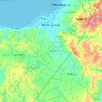
Name: Kabankalan topographic map, elevation, terrain.

Location: Kabankalan, Negros Occidental, Western Visayas, 6111, Philippines (9.57669 122.71752 10.12197 122.98095)

Average elevation: 886 ft

Minimum elevation: -3 ft

Maximum elevation: 4,692 ft

Other topographic maps

Click on a map to view its topography, its elevation and its terrain.

Kabankalan

Philippines > Negros Occidental

Average elevation: 486 ft

Minoyan

Philippines > Negros Occidental > Murcia

Average elevation: 991 ft

Tinagong Dagat

Philippines > Negros Occidental > Talisay

Average elevation: 4,478 ft

Bagumbayan

Philippines > Negros Occidental > Valladolid

Average elevation: 10 ft

Lumbia

Philippines > Negros Occidental > Cauayan

Average elevation: 686 ft

Banquerohan

Philippines > Negros Occidental > Cadiz

Average elevation: 23 ft

Tagukon

Philippines > Negros Occidental > Kabankalan

Average elevation: 423 ft

Anahaw

Philippines > Negros Occidental > Hinigaran

Average elevation: 43 ft

Concepcion

Philippines > Negros Occidental > Talisay

Average elevation: 505 ft

Canlubang

Philippines > Negros Occidental

Average elevation: 20 ft

Sibato

Philippines > Negros Occidental > Silay > Sibato

Average elevation: 853 ft

Patag Diotay

Philippines > Negros Occidental > Silay

Average elevation: 1,145 ft

Central

Philippines > Negros Occidental > Sagay > Central

Average elevation: 102 ft

Gear up for your next adventure:

👓Polarized Sunglasses - Outdoor sunglasses for glare reduction
🎁Geography Themed Gifts - Unique gift ideas for map lovers and geography enthusiasts
🦺Reflective Outdoor Gear - Safety gear for low‑light conditions
🎒Waterproof Dry Bags - Keep your electronics and maps dry inside your pack
🛌Ultralight Sleeping Bags - Compact down bags for cold nights in the wilderness

As an Amazon Associate, this site earns from qualifying purchases at no extra cost to you.