
Ribadeume topographic map
Interactive map
Click on the map to display elevation.
About this map
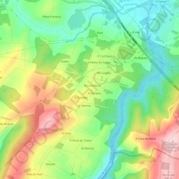
Name: Ribadeume topographic map, elevation, terrain.
Average elevation: 1,391 ft
Minimum elevation: 1,056 ft
Maximum elevation: 1,864 ft
Other topographic maps
Click on a map to view its topography, its elevation and its terrain.
O Paraño
España > Galicia > Eume > As Pontes de García Rodríguez
O Paraño, As Pontes de García Rodríguez, Eume, La Coruña, Galicia, 15320, España
Average elevation: 1,516 ft