
Make a donation
Gear up for your next adventure:
As an Amazon Associate, this site earns from qualifying purchases at no extra cost to you.
Sitia Municipal Unit topographic map
Click on the map to display elevation.
Make a donation
Gear up for your next adventure:
As an Amazon Associate, this site earns from qualifying purchases at no extra cost to you.
About this map
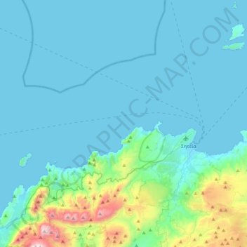
Name: Sitia Municipal Unit topographic map, elevation, terrain.
Average elevation: 535 ft
Minimum elevation: -3 ft
Maximum elevation: 4,491 ft
Make a donation
Gear up for your next adventure:
As an Amazon Associate, this site earns from qualifying purchases at no extra cost to you.
Other topographic maps
Click on a map to view its topography, its elevation and its terrain.
Ρίζα
Greece > Region of Crete > Lasithi Regional Unit > Ierapetra Municipal Unit
Average elevation: 1,814 ft
Sisi
Greece > Region of Crete > Lasithi Regional Unit > Vrachasi Municipal Unit
Average elevation: 190 ft
Vrachasi
Greece > Region of Crete > Lasithi Regional Unit > Vrachasi Municipal Unit
Average elevation: 1,191 ft
Ierapetra
Greece > Region of Crete > Lasithi Regional Unit > Ierapetra Municipal Unit
Average elevation: 115 ft
Make a donation
Gear up for your next adventure:
As an Amazon Associate, this site earns from qualifying purchases at no extra cost to you.
Milatos
Greece > Region of Crete > Lasithi Regional Unit > Neapoli Municipal Unit
Average elevation: 410 ft
Stavromenos
Greece > Region of Crete > Lasithi Regional Unit > Sitia Municipal Unit
Average elevation: 974 ft
Tsifliki
Greece > Region of Crete > Lasithi Regional Unit > Agios Nikolaos Municipal Unit
Average elevation: 351 ft
Make a donation
Gear up for your next adventure:
As an Amazon Associate, this site earns from qualifying purchases at no extra cost to you.
Sitia
Greece > Region of Crete > Lasithi Regional Unit > Sitia Municipal Unit
Average elevation: 210 ft
Choumeriakos
Greece > Region of Crete > Lasithi Regional Unit > Neapoli Municipal Unit
Average elevation: 1,056 ft
Make a donation
Gear up for your next adventure:
As an Amazon Associate, this site earns from qualifying purchases at no extra cost to you.
Agios Nikolaos
Greece > Region of Crete > Lasithi Regional Unit > Agios Nikolaos Municipal Unit
Average elevation: 230 ft
Sitia
Greece > Region of Crete > Lasithi Regional Unit > Sitia Municipal Unit
Average elevation: 210 ft