Geolocate

Leuchars topographic map

Click on the map to display elevation.

About this map

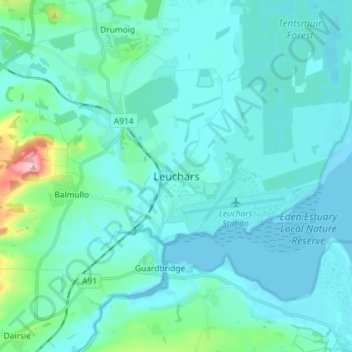
Name: Leuchars topographic map, elevation, terrain.

Location: Leuchars, Fife, Scotland, KY16 0HH, United Kingdom (56.34141 -2.92389 56.42141 -2.84389)

Average elevation: 72 ft

Minimum elevation: -10 ft

Maximum elevation: 614 ft

Gear up for your next adventure:

🛡️Bear Spray Outdoor - Protection in bear country hikes
🗃️Trail First Aid Kit - Essential kit for outdoor injuries and emergencies
📡GPS Antenna Upgrade - Enhance GPS reception in remote terrain
🌐World Map Poster - Decorative world maps with topographic info
🌲Outdoor Survival Books - Best books on survival skills

As an Amazon Associate, this site earns from qualifying purchases at no extra cost to you.