
Les Amans topographic map
Interactive map
Click on the map to display elevation.
About this map
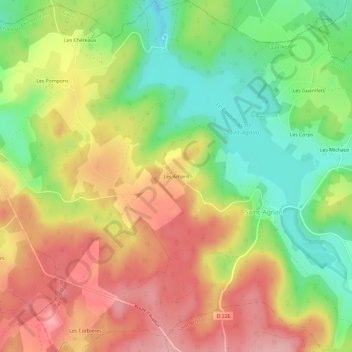
Name: Les Amans topographic map, elevation, terrain.
Average elevation: 1,883 ft
Minimum elevation: 1,657 ft
Maximum elevation: 2,100 ft
Other topographic maps
Click on a map to view its topography, its elevation and its terrain.
Barrage de Saint-Agnan
France > Bourgogne-Franche-Comté > Nièvre > Saint-Agnan
Barrage de Saint-Agnan, Saint-Agnan, Château-Chinon (Ville), Nièvre, Bourgogne-Franche-Comté, France métropolitaine, 58230, France
Average elevation: 1,801 ft
Les Michaux
France > Bourgogne-Franche-Comté > Nièvre > Saint-Agnan > Les Michaux
Les Michaux, Saint-Agnan, Château-Chinon (Ville), Nièvre, Bourgogne-Franche-Comté, France métropolitaine, 58230, France
Average elevation: 1,831 ft
Les Corps
France > Bourgogne-Franche-Comté > Nièvre > Saint-Agnan
Les Corps, Saint-Agnan, Château-Chinon (Ville), Nièvre, Bourgogne-Franche-Comté, France métropolitaine, 58230, France
Average elevation: 1,824 ft
Lac de Saint-Agnan
France > Bourgogne-Franche-Comté > Nièvre > Saint-Agnan
Lac de Saint-Agnan, Saint-Agnan, Château-Chinon (Ville), Nièvre, Bourgogne-Franche-Comté, France métropolitaine, 58230, France
Average elevation: 1,808 ft