
Yeovil topographic map
Interactive map
Click on the map to display elevation.
About this map
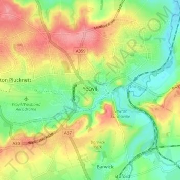
Name: Yeovil topographic map, elevation, terrain.
Location: Yeovil, South Somerset, Somerset, England, United Kingdom (50.92679 -2.67151 50.95660 -2.59799)
Average elevation: 207 ft
Minimum elevation: 72 ft
Maximum elevation: 371 ft
Other topographic maps
Click on a map to view its topography, its elevation and its terrain.
Aller
United Kingdom > England > Somerset > South Somerset
Aller, South Somerset, Somerset, England, TA10 0QZ, United Kingdom
Average elevation: 92 ft
Broad River
United Kingdom > England > Somerset > South Somerset > West Chinnock
Broad River, West Chinnock, South Somerset, Somerset, England, TA18 7PL, United Kingdom
Average elevation: 200 ft