Geolocate

Aller topographic map

Click on the map to display elevation.

About this map

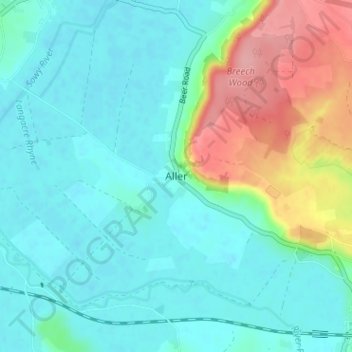
Name: Aller topographic map, elevation, terrain.

Location: Aller, South Somerset, Somerset, England, TA10 0QZ, United Kingdom (51.03934 -2.87716 51.07934 -2.83716)

Average elevation: 92 ft

Minimum elevation: 3 ft

Maximum elevation: 354 ft

Other topographic maps

Click on a map to view its topography, its elevation and its terrain.

Gear up for your next adventure:

🩹Survival Bandages - High‑quality bandages for emergencies
🪶Wildlife Field Guides - Learn animal tracking and species ID
🎒Gear Packing Cubes - Organize your backpack efficiently
🎒Day Hiking Backpack - Lightweight backpack perfect for day trips and outdoor adventures
🥾Hiking Shoes - Durable and comfortable shoes for trail hiking

As an Amazon Associate, this site earns from qualifying purchases at no extra cost to you.