
Río Limarí topographic map
Interactive map
Click on the map to display elevation.
About this map
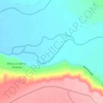
Name: Río Limarí topographic map, elevation, terrain.
Average elevation: 509 ft
Minimum elevation: 341 ft
Maximum elevation: 873 ft
Other topographic maps
Click on a map to view its topography, its elevation and its terrain.
Parque Nacional Bosque de Fray Jorge
Chile > Región de Coquimbo > Ovalle
Parque Nacional Bosque de Fray Jorge, Cruce Longitudinal (Cerrillos Pobres) - Fray Jorge, Ovalle, Provincia de Limarí, Región de Coquimbo, Chile
Average elevation: 564 ft