
Kirchberg in Tirol topographic map
Interactive map
Click on the map to display elevation.
About this map
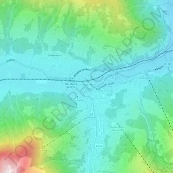
Name: Kirchberg in Tirol topographic map, elevation, terrain.
Location: Kirchberg in Tirol, Bezirk Kitzbühel, Tirol, 6365, Österreich (47.42759 12.29445 47.46759 12.33445)
Average elevation: 3,245 ft
Minimum elevation: 2,530 ft
Maximum elevation: 5,768 ft
Dörfer: Bockern • Kirchberg in Tirol • Klausen • Spertendorf | Weiler: Katzendorf | Rotten: Aschau • Grafen • Innere Kleinseite | Häusergruppe: Wötzing | Zerstreute Häuser: Äußere Kleinseite • Brandseite • Ehrenbachhöhe • Gaisberg • Gründau • Issbühel • Krinberg • Sonnberg • Usterberg Sonstige Ortslagen: Bärstättalm • Jager • Kobingerhütte • Labalm • Oberlandhütte