
Tinzouline topographic map
Interactive map
Click on the map to display elevation.
About this map
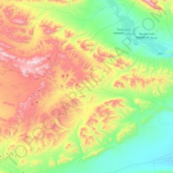
Name: Tinzouline topographic map, elevation, terrain.
Average elevation: 3,655 ft
Minimum elevation: 2,431 ft
Maximum elevation: 5,682 ft
Other topographic maps
Click on a map to view its topography, its elevation and its terrain.
M'Hamid El Ghizlane
M'Hamid El Ghizlane, caïdat de M'Hamid, Cercle de Zagora, Province de Zagora, Drâa-Tafilalet, Maroc
Average elevation: 2,106 ft