
Thank you for supporting this site ❤️
Make a donation
Make a donation
Gear up for your next adventure:
As an Amazon Associate, this site earns from qualifying purchases at no extra cost to you.
Kumelembuai topographic map
Click on the map to display elevation.
Thank you for supporting this site ❤️
Make a donation
Make a donation
Gear up for your next adventure:
As an Amazon Associate, this site earns from qualifying purchases at no extra cost to you.
About this map
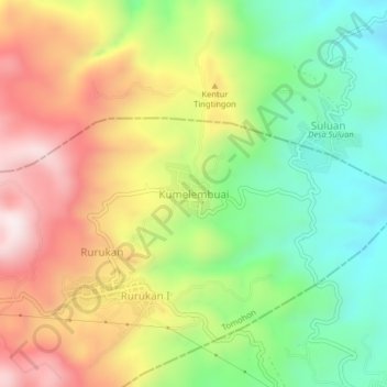
Name: Kumelembuai topographic map, elevation, terrain.
Location: Kumelembuai, North Sulawesi, Indonesia (1.32896 124.86734 1.36896 124.90734)
Average elevation: 3,002 ft
Minimum elevation: 2,005 ft
Maximum elevation: 4,199 ft
Thank you for supporting this site ❤️
Make a donation
Make a donation
Gear up for your next adventure:
As an Amazon Associate, this site earns from qualifying purchases at no extra cost to you.