
Ribeira de Cagavai topographic map
Interactive map
Click on the map to display elevation.
About this map
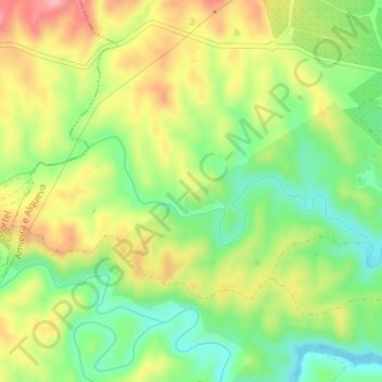
Name: Ribeira de Cagavai topographic map, elevation, terrain.
Average elevation: 679 ft
Minimum elevation: 486 ft
Maximum elevation: 909 ft
Other topographic maps
Click on a map to view its topography, its elevation and its terrain.
Alqueva
Portugal > Alentejo > Amieira e Alqueva
Alqueva, Amieira e Alqueva, Portel, Évora, Alentejo Central, Alentejo, Portugal
Average elevation: 584 ft
Amieira
Portugal > Alentejo > Amieira e Alqueva
Amieira, Amieira e Alqueva, Portel, Évora, Alentejo Central, Alentejo, Portugal
Average elevation: 719 ft