
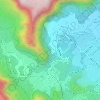
Ravine Sèche topographic map
Interactive map
Click on the map to display elevation.
About this map
Name: Ravine Sèche topographic map, elevation, terrain.
Average elevation: 4,022 ft
Minimum elevation: 3,474 ft
Maximum elevation: 5,400 ft
Other topographic maps
Click on a map to view its topography, its elevation and its terrain.
Ravine-Bras-Creux
France > La Réunion > La Plaine-des-Palmistes > Bras des Calumets
Ravine-Bras-Creux, Bras des Calumets, La Plaine-des-Palmistes, Saint-Benoît, La Réunion, 97431, France
Average elevation: 4,406 ft
Bras des Calumets
France > La Réunion > La Plaine-des-Palmistes
Bras des Calumets, La Plaine-des-Palmistes, Saint-Benoît, La Réunion, 97431, France
Average elevation: 4,219 ft
Petite Plaine
France > La Réunion > La Plaine-des-Palmistes > Petite Plaine
Petite Plaine, La Plaine-des-Palmistes, Saint-Benoît, La Réunion, 97431, France
Average elevation: 4,140 ft