
Make a donation
Gear up for your next adventure:
As an Amazon Associate, this site earns from qualifying purchases at no extra cost to you.
Pamplona topographic map
Click on the map to display elevation.
Make a donation
Gear up for your next adventure:
As an Amazon Associate, this site earns from qualifying purchases at no extra cost to you.
Pamplona
The climate of Pamplona is classified as an oceanic climate (Köppen climate classification: Cfb) with influences of a Mediterranean climate (Csb). Due to global warming and stronger summer heat waves in the 21st century, it is also on the boundary with a humid subtropical climate (Cfa). Precipitation patterns do not vary much over the course of the year, as is typical of marine climates, but both classifications are possible due to the Mediterranean patterns of somewhat drier summer months. Sunshine hours are typical for a location in Northern Spain, thus more similar to the oceanic coastal climate in nearby Basque locations than typical Spanish Mediterranean areas are, but rainfall is significantly lower than in Bilbao and especially San Sebastián, as well as the climate is harsher than in the northern coastal areas (colder winter lows, warmer summer highs) because of the altitude of 450 metres (1,480 ft) and its inland location.
Make a donation
Gear up for your next adventure:
As an Amazon Associate, this site earns from qualifying purchases at no extra cost to you.
About this map
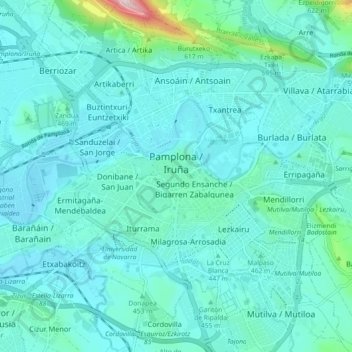
Name: Pamplona topographic map, elevation, terrain.
Location: Pamplona, Iruñerria / Comarca de Pamplona, Navarre, Spain (42.78874 -1.69538 42.84244 -1.60449)
Average elevation: 1,463 ft
Minimum elevation: 1,319 ft
Maximum elevation: 2,579 ft
Make a donation
Gear up for your next adventure:
As an Amazon Associate, this site earns from qualifying purchases at no extra cost to you.
Other topographic maps
Click on a map to view its topography, its elevation and its terrain.
Zulueta
Spain > Navarre > Iruñerria / Comarca de Pamplona > Valle de Elorz / Elortzibar
Average elevation: 1,713 ft