
Make a donation
Gear up for your next adventure:
As an Amazon Associate, this site earns from qualifying purchases at no extra cost to you.
Cerro de la Cruz topographic map
Click on the map to display elevation.
Make a donation
Gear up for your next adventure:
As an Amazon Associate, this site earns from qualifying purchases at no extra cost to you.
About this map
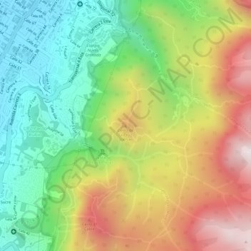
Name: Cerro de la Cruz topographic map, elevation, terrain.
Average elevation: 9,521 ft
Minimum elevation: 8,445 ft
Maximum elevation: 10,833 ft
Make a donation
Gear up for your next adventure:
As an Amazon Associate, this site earns from qualifying purchases at no extra cost to you.
Other topographic maps
Click on a map to view its topography, its elevation and its terrain.
Bogota
Colombia > Bogota, Capital District
Bogotá is located in the southeastern part of the Bogotá savanna (Sabana de Bogotá) at an average altitude of 2,640 meters (8,660 ft) above sea level. The Bogotá savanna is popularly called "savannah" (sabana), but constitutes actually a high plateau in the Andes mountains, part of an extended region known…
Average elevation: 8,894 ft
Bogota
Colombia > Bogota, Capital District
The city is located in the center of Colombia, on a high plateau known as the Bogotá savanna, part of the Altiplano Cundiboyacense located in the Eastern Cordillera of the Andes. Its altitude averages 2,640 meters (8,660 ft) above sea level. Subdivided into 20 localities, Bogotá covers an area of 1,587…
Average elevation: 8,894 ft
Bogota
Colombia > Bogota, Capital District
Bogotá is located in the southeastern part of the Bogotá savanna (Sabana de Bogotá) at an average altitude of 2,640 meters (8,660 ft) above sea level. The Bogotá savanna is popularly called "savannah" (sabana), but constitutes actually a high plateau in the Andes mountains, part of an extended region known…
Average elevation: 8,894 ft
Bogota Capital District - Municipality
Colombia > Bogota, Capital District
The city is located in the center of Colombia, on a high plateau known as the Bogotá savanna, part of the Altiplano Cundiboyacense located in the Eastern Cordillera of the Andes. Its altitude averages 2,640 meters (8,660 ft) above sea level. Subdivided into 20 localities, Bogotá has an area of 1,587 square…
Average elevation: 7,162 ft
Make a donation
Gear up for your next adventure:
As an Amazon Associate, this site earns from qualifying purchases at no extra cost to you.
Bogota
Colombia > Bogota, Capital District
The city is located in the center of Colombia, on a high plateau known as the Bogotá savanna, part of the Altiplano Cundiboyacense located in the Eastern Cordillera of the Andes. Its altitude averages 2,640 meters (8,660 ft) above sea level, making it the third highest capital city in the world. Subdivided…
Average elevation: 8,898 ft
Bogota
Colombia > Bogota, Capital District
The city is located in the center of Colombia, on a high plateau known as the Bogotá savanna, part of the Altiplano Cundiboyacense located in the Eastern Cordillera of the Andes. Its altitude averages 2,640 meters (8,660 ft) above sea level, making it the third highest capital city in the world. Subdivided…
Average elevation: 8,894 ft
Bogota
Colombia > Bogota, Capital District
The city is located in the center of Colombia, on a high plateau known as the Bogotá savanna, part of the Altiplano Cundiboyacense located in the Eastern Cordillera of the Andes. Its altitude averages 2,640 meters (8,660 ft) above sea level. Subdivided into 20 localities, Bogotá has an area of 1,587 square…
Average elevation: 8,894 ft
Make a donation
Gear up for your next adventure:
As an Amazon Associate, this site earns from qualifying purchases at no extra cost to you.
Bogota
Colombia > Bogota, Capital District
The city is located in the center of Colombia, on a high plateau known as the Bogotá savanna, part of the Altiplano Cundiboyacense located in the Eastern Cordillera of the Andes. Its altitude averages 2,640 meters (8,660 ft) above sea level. Subdivided into 20 localities, Bogotá covers an area of 1,587…
Average elevation: 8,898 ft
Bogota
Colombia > Bogota, Capital District
The city is located in the center of Colombia, on a high plateau known as the Bogotá savanna, part of the Altiplano Cundiboyacense located in the Eastern Cordillera of the Andes. Its altitude averages 2,640 meters (8,660 ft) above sea level. Subdivided into 20 localities, Bogotá covers an area of 1,587…
Average elevation: 8,894 ft
Bogota Capital District - Municipality
Colombia > Bogota, Capital District
Bogotá is located in the southeastern part of the Bogotá savanna (Sabana de Bogotá) at an average altitude of 2,640 meters (8,660 ft) above sea level. The Bogotá savanna is popularly called "savannah" (sabana), but constitutes actually a high plateau in the Andes mountains, part of an extended region known…
Average elevation: 7,005 ft