
Souidania topographic map
Interactive map
Click on the map to display elevation.
About this map
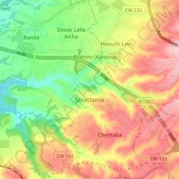
Name: Souidania topographic map, elevation, terrain.
Location: Souidania, Daïra Zéralda, Alger, 16097, Algérie (36.68535 2.87373 36.73623 2.93373)
Average elevation: 446 ft
Minimum elevation: 171 ft
Maximum elevation: 705 ft
Other topographic maps
Click on a map to view its topography, its elevation and its terrain.
Khaiti Ahmed
Algérie > Alger > Daïra Zéralda > Staoueli
Khaiti Ahmed, Staoueli, Daïra Zéralda, Alger, 16102, Algérie
Average elevation: 203 ft