
Balule Nature Reserve topographic map
Interactive map
Click on the map to display elevation.
About this map
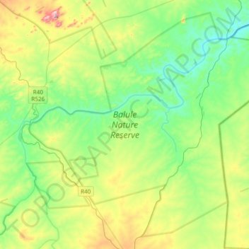
Name: Balule Nature Reserve topographic map, elevation, terrain.
Average elevation: 1,450 ft
Minimum elevation: 1,020 ft
Maximum elevation: 2,474 ft
Other topographic maps
Click on a map to view its topography, its elevation and its terrain.
Zandspruit
South Africa > Limpopo > Maruleng Local Municipality
Zandspruit, Maruleng Ward 2, Maruleng Local Municipality, Limpopo, South Africa
Average elevation: 1,775 ft
Hoedspruit
South Africa > Limpopo > Maruleng Local Municipality
Hoedspruit, Maruleng Local Municipality, Limpopo, South Africa
Average elevation: 1,719 ft
Kampersrus AH
South Africa > Limpopo > Maruleng Local Municipality
Kampersrus AH, Maruleng Local Municipality, Mopani District Municipality, Limpopo, South Africa
Average elevation: 2,726 ft