
Alvão topographic map
Interactive map
Click on the map to display elevation.
About this map
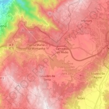
Name: Alvão topographic map, elevation, terrain.
Average elevation: 2,890 ft
Minimum elevation: 679 ft
Maximum elevation: 3,967 ft
Other topographic maps
Click on a map to view its topography, its elevation and its terrain.
Gouvães da Serra
Gouvães da Serra, Alvão, Vila Pouca de Aguiar, Vila Real, Alto Tâmega, Norte, Portugal
Average elevation: 3,232 ft
Santa Marta da Montanha
Santa Marta da Montanha, Alvão, Vila Pouca de Aguiar, Vila Real, Alto Tâmega, Norte, Portugal
Average elevation: 2,989 ft