
Remich topographic map
Interactive map
Click on the map to display elevation.
About this map
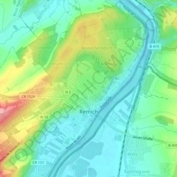
Name: Remich topographic map, elevation, terrain.
Location: Remich, Canton Remich, Luxembourg (49.53424 6.33917 49.56146 6.38177)
Average elevation: 564 ft
Minimum elevation: 449 ft
Maximum elevation: 820 ft
Other topographic maps
Click on a map to view its topography, its elevation and its terrain.
Brill
Luxembourg > Canton Remich > Altwies
Brill, Altwies, Mondorf-les-Bains, Canton Remich, 5611, Luxembourg
Average elevation: 751 ft