Geolocate

Looc topographic map

Click on the map to display elevation.

About this map

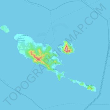
Name: Looc topographic map, elevation, terrain.

Location: Looc, Occidental Mindoro, Mimaropa, 5111, Philippines (13.55429 120.09760 13.99950 120.56223)

Average elevation: 33 ft

Minimum elevation: 0 ft

Maximum elevation: 2,398 ft

Other topographic maps

Click on a map to view its topography, its elevation and its terrain.

Lumibay

Philippines > Occidental Mindoro > Lubang

Average elevation: 138 ft

Mapaya

Philippines > Occidental Mindoro > San Jose

Average elevation: 33 ft

Purnaga

Philippines > Occidental Mindoro > Magsaysay

Average elevation: 253 ft

Sto. Niño

Philippines > Occidental Mindoro > Sablayan

Average elevation: 43 ft

Bato River

Philippines > Occidental Mindoro > Santa Cruz

Average elevation: 10 ft

Cabra Island

Philippines > Occidental Mindoro > Lubang

With a length of about 4.5 km (2.8 miles) and about 2.9 km (1.8 miles) at its widest, the island has a flat terrain with the highest elevation at 60.96 metres (around 200 feet). A particular rock islet near one beach is considered by locals as a symbol of the island given its shape as a cabra (Spanish for…

Average elevation: 56 ft

Gear up for your next adventure:

🧦Merino Wool Socks - Moisture-wicking, blister-preventing socks for long treks
🌧️Backpack Rain Cover - Keep gear dry in wet weather
🚪Portable Camp Chair - Foldable chair for comfort at camp
🎒Day Hiking Backpack - Lightweight backpack perfect for day trips and outdoor adventures
📚Navigation Handbooks - Master the art of reading topographic maps and using a compass

As an Amazon Associate, this site earns from qualifying purchases at no extra cost to you.