
Masseyville topographic map
Interactive map
Click on the map to display elevation.
About this map
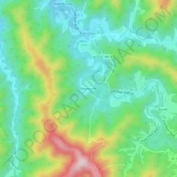
Name: Masseyville topographic map, elevation, terrain.
Average elevation: 1,742 ft
Minimum elevation: 1,266 ft
Maximum elevation: 2,769 ft
Other topographic maps
Click on a map to view its topography, its elevation and its terrain.
Pluto
United States > West Virginia > Raleigh County > Pluto
Pluto, Raleigh County, West Virginia, United States
Average elevation: 2,844 ft
Beckley
United States > West Virginia > Raleigh County
Beckley, Raleigh County, West Virginia, 25801, United States
Average elevation: 2,372 ft