
Guédiawaye Department topographic map
Interactive map
Click on the map to display elevation.
About this map
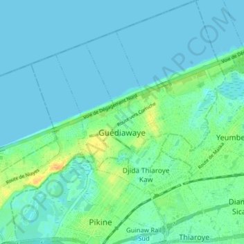
Name: Guédiawaye Department topographic map, elevation, terrain.
Location: Guédiawaye Department, Dakar Region, 15000, Senegal (14.74523 -17.43007 14.81476 -17.35960)
Average elevation: 20 ft
Minimum elevation: 0 ft
Maximum elevation: 92 ft
Other topographic maps
Click on a map to view its topography, its elevation and its terrain.
Commune de Ngor
Senegal > Dakar Region > Dakar
Commune de Ngor, Arrondissement des Almadies, Dakar, Dakar Region, 18524, Senegal
Average elevation: 23 ft
Guédiawaye Arrondissement
Senegal > Dakar Region > Guédiawaye Department
Guédiawaye Arrondissement, Guédiawaye Department, Dakar Region, Senegal
Average elevation: 20 ft