
Twee-Akren topographic map
Interactive map
Click on the map to display elevation.
About this map
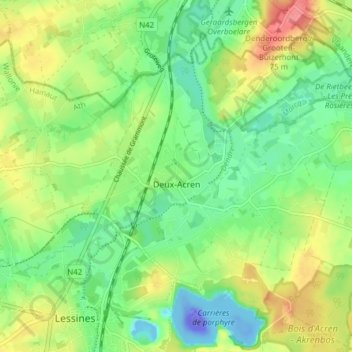
Name: Twee-Akren topographic map, elevation, terrain.
Location: Twee-Akren, Lessen, Aat, Henegouwen, Wallonië, 7864, België (50.71217 3.82258 50.75161 3.89908)
Average elevation: 95 ft
Minimum elevation: -361 ft
Maximum elevation: 253 ft
Other topographic maps
Click on a map to view its topography, its elevation and its terrain.
Deux Acren
België > Henegouwen > Aat > Lessen > Twee-Akren
Deux Acren, Twee-Akren, Lessen, Aat, Henegouwen, Wallonië, 7860, België
Average elevation: 85 ft