
Make a donation
Gear up for your next adventure:
As an Amazon Associate, this site earns from qualifying purchases at no extra cost to you.
Conyers topographic map
Click on the map to display elevation.
Make a donation
Gear up for your next adventure:
As an Amazon Associate, this site earns from qualifying purchases at no extra cost to you.
About this map
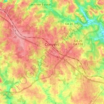
Name: Conyers topographic map, elevation, terrain.
Location: Conyers, Rockdale County, Georgia, United States (33.62497 -84.04573 33.69510 -83.92308)
Average elevation: 823 ft
Minimum elevation: 633 ft
Maximum elevation: 958 ft
Rockdale County trails, hiking, mountain biking, running and outdoor activities
Make a donation
Gear up for your next adventure:
As an Amazon Associate, this site earns from qualifying purchases at no extra cost to you.
Other topographic maps
Click on a map to view its topography, its elevation and its terrain.
Georgia International Horse Park
United States > Georgia > Rockdale County > Conyers
Average elevation: 712 ft
Make a donation
Gear up for your next adventure:
As an Amazon Associate, this site earns from qualifying purchases at no extra cost to you.